#2 Dalton Highway Wiseman to Dead Horse-Prudhoe Bay
 Leaving Wiseman, traveling the 3 miles back to the Dalton Highway,we cross over Middle Fork Koyukuk River No.1. There are 3 sections of
Middle Fork.


This awe-inspiring massive wall of granite, the Sukakpak Mountain (elevation 4,459 feet), often glows in the afternoon sun. Sukakpak Mountain, the Eskimo and Indians believe is the traditional boundary between the Eskimo and Athabascan Indian territories. There are no other mountains along the entire route of the Dalton Highway that look like these. Notice the tailings at the bottom of the rock. Tailings result as the granite is slowly worn down by winds and weather.

We pass through the northern edge of the Alaska Mountain Range, which extend all the way to Seward, on our way to the Brooks Mt. Range.

As we contine northward, the trees grow scarce until they disappear altogether. This tall spruce (right) was approximagtely 273 years old when it was killed by vandals in 2004. The pipeline owns the property upon which the tree sits and contine to attemt to save the tree for further destruction.

The hillsides are alive with the beauty of fall colors.
Approaching the Brooks Range


Dramatic views encompass the headwaters of the Chandalar River (left).

Crossing over the Chandalar Shelf, the next couple miles traverse a major winter avalanche zone. To the right is one of those 12 percent grades we mentioned before.

Taking a moment to look back at the Chandalar Shelf (left) before we climb up toward, to and through the Atigun Pass of the Brooks Mountain Range. We could hardly believe how amazing the landscape was and how quickly it was changing. Our heads just kept swiveling back and forth attempting to take it all in.

Someone once commented about the vast panoramic view of the Brooks Range and that it was like seeing "endless mountains rising and falling as if the waves of snow of some gigantic ocean had suddenly become frozen in full motion". That is a very good description.

Yup, there sure could be avalanches here in the Brooks Range. Steep rocky slopes and glacier-carved valleys dominate this rugged landscape of the Brooks Mountain Range Brooks Range extends over 7,000 miles east to west, creating a formidable barrier across the Arctic for plants, birds and weather systems.

The Alaska state transportation workers stationed here fire artillery shells from this mounted apparatus (above), to clear the slopes of snow in the winter, above the highway.

Looking back to the Atigun Pass and the Brooks Mountain Range (elevation 4,739 feet), we have crossed the Continental Divide. Rivers south of here flow into the Pacific Ocean or Bering Sea, while rivers to the north flow into the Arctic Ocean. The views in person are breathtaking!

Galbraith Lake (right) is all that remains of a large glacial lake that once occupied the entire Atigun Valley.
This far north, the sun never sets between May 10th and August 2nd. It doesn't rise between November 18th and January 23rd. Talk about wintertime/no light depression!

For approximately 90 miles we travel along side the Arctic National Wildlife Refuge. The entire Refuge extends east across the Brooks Range and North Slope to Canada, offering extraordinary value to the wilderness, recreation and wildlife. Caribou herds migrate through the Refuge. Polar bears, muskoxen and snow geese depend on the unspoiled environment. Alaska Pioneer conservationists Margaret and Olaus Murie, whom I read about in their published novel about their life in the Alasa Bush, traveled the region by dog team and canoe in the early 20th century. They were instrumental in gaining refuge status for the area.


The fall colors of oranges, yellows and reds of the tundra are as beautiful and as different from the fall colors of leaves Outside. (Outside = lower 48 States)

There is a large amount of Bureau of Land Management (BLM) land along the Highway and bow season for Caribou was open. We saw an amazing number of camps set up just off the highway. The weather was pretty windy and in the 40's. Too cold for me to tent. At a couple sites we spotted Caribou antlers like the ones seen here (right). We thought they had most likely been found rather than a Caribou shot, as the animals do loose their amazingly large antlers every year.
The Caribou should have been easy to spot on these open tundra fields. The saving grace was all the rolling hills for the Caribou to "hide" behind. We would see hunters going in one direction
then down the road a piece we would spot a Caribou on the opposite side of the road; nary a hunter was around.
In places where a large drop off into the soft and mushy landscape might occur, the road crew graded and banked the highway edges for weary travelers. The picture left above, gives a good glimpse looking back, of the largeness of the Brooks Mountain Range. We are perhaps 100 miles north of those mountains.
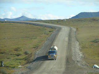
I kept track of how many 18-wheelers passed us going south as we were headed north, as well as tacking the number of passenger vehicles going south. I was astonished that the 18-wheelers were only 1/3 of the traffic population. We had expected a lot more truck traffic.
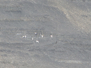
Finally, finally we see Dall Sheep. There are a few places along the Haul Road where calcium chloride is put on the roads, for dust control, which draws the sheep onto the highway to lick the salt. None were there when we passed those areas. Even if the sheep are at a distance, it was still fun to spot them.
West of the Dalton Highway lies the Gates of the Arctic National Park and Preserve. It is one of the premier wilderness areas in the National Park System. (See another reason to take this northbound road-to get my National Parks passbook stamped, proof of having visited yet another National Park.) The area was explored in the 1930's by Robert Marshall. Being impressed by the two massive peaks flanking the North Fork of the Koyukuk River he called them the "Gates of the Arctic". The National Park and Preserve encompasses 8.4 million acres protecting primeval landscapes, their flora and fauna and the culture and traditions of Native peoples.

The small mounds seen in the picture to the right are referred to as Palsen's. They are developing mounds with cores of ice and peat which
rise up as ground water moves down slope, through the soil above the permafrost and freezes.

Just as Don said "we need to see some Muskoxen for Jerry", low and behold trying to hide just behind the wall of Fireweed flowers, appears a Muskox. They are not particularly cooperative animals and he never did raise his head for a more proper picture with his face in it. More often Muskox are seen farther from the road and appear as no more than a brown bump with lighter blond coloring on top of the bump. We were very lucky to see one this close. (All for you, Jerry Funk.)
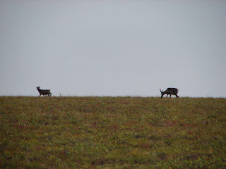
Remember those hunters? These wise Caribou (right) are keeping an eye on them by sticking to the top ridges of the hills.
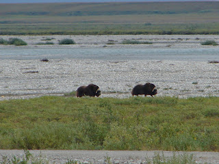
About 20 miles out of Dead Horse we spotted a herd of Muskox and these two patrolling the defense lines, so to speak. As herds last year lost 4 babies and this year 3 babies, to wolves and/or bear, the family units stick closer together ready to defend the herd. One herd we saw on the way back was close enough to the road to get a picture of a baby, however, one of the males walked right in front of it and stopped...good protection, I'd say. Protecting that baby from even a picture being taken of it.
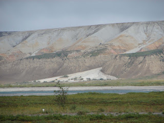
The bluffs to the right have been named the Franklin Bluffs after Sir John Franklin, the British explorer who mapped the arctic coastline in search of the Northwest Passage.
The iron-rich soils along the banks of the river give the bluffs their vivid colors. Seeing the white rock of these bluffs and the yellows, pinks, browns and orange colors running through the base white rock, and I thought I looking at gigantic slabs of the quartz mineral. It is a stunning view if you are lucky enough to see them in the sunlight. Yes, that is snow just above the rivers edge. It was foggy and cloudy on the way back south. Yet another reason to take pictures as you see them, not wait until later.

In the North Slope area only tough, ground-hugging plants can survive the frozen ground, frigid temperatures, icy winds and weak sunlight.
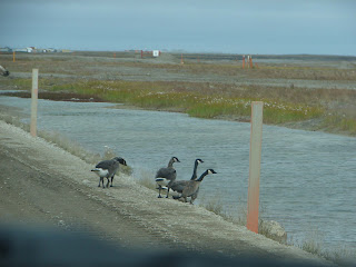
The Arctic Cotton thrives here in the water sodden fields. With annual precipitation of about 5 inches and the underlying permafrost, the ground is sealed and water doesn't sink in. The water staying on the surface creating vast wetlands enables protein-rich sedges to grow, huge populations of insects to live and thrive and provides a banquet for migratory birds and other wildlife. These Greater White-fronted Geese don't seem to mind the windy, cold weather much while enjoying some good eats.
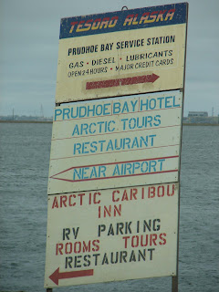
Reaching this sign indicates we have reached the end of the
Dalton Highway and safely driven 1/2 of the 1,000 miles round trip. We have arrived in Dead Horse, Prudhoe Bay.

And there is even a welcoming sign to verify we have indeed reached Deadhorse Alaska, the end of the Dalton Highway.
Being smaller in stature than the Canada Geese, these geese willing to brave the frigid temperatures of nearby ponds are Traverna's Crackling Geese.

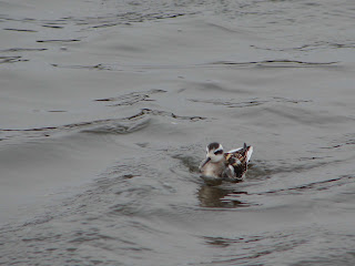
Northern female Pintail
 There were a bunch of these adorable juvenial Red-necked Phalarope', frantic, constantly moving either in circles or back and forth, in this pond. A new "lifer" duck for me and difficult to figure out. I remain confident in the name of this pretty duck because I was able to see tinges of red around his neck and I got flat out tired of looking and trying to decide!
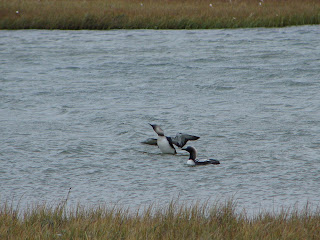
Pacific Loons, even though I wanted them to be a different Loon than we have already seen on this trip.
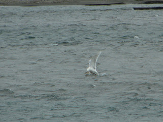
And finally, I remain conflicted about this seagull. Much material suggests Sabine's Seagulls are found on the Arctic Coast; off chance it might be a black-legged Kittiwake, which we saw nesting in Valdez. At any rate, this glorious seagull has plucked his fish dinner out of the river. Look carefully and you will see the bird has the fish firmly in his beak, across the middle of the fish. (head of fish to right, tail of fish to left of seagulls beak)
Now that we have made it to Prudhoe Bay/Deadhorse blog #3 of the Dalton Highway will give you a taste of what the area looks like. BBFN, Karen and Don

then down the road a piece we would spot a Caribou on the opposite side of the road; nary a hunter was around.
In places where a large drop off into the soft and mushy landscape might occur, the road crew graded and banked the highway edges for weary travelers. The picture left above, gives a good glimpse looking back, of the largeness of the Brooks Mountain Range. We are perhaps 100 miles north of those mountains.

I kept track of how many 18-wheelers passed us going south as we were headed north, as well as tacking the number of passenger vehicles going south. I was astonished that the 18-wheelers were only 1/3 of the traffic population. We had expected a lot more truck traffic.

Finally, finally we see Dall Sheep. There are a few places along the Haul Road where calcium chloride is put on the roads, for dust control, which draws the sheep onto the highway to lick the salt. None were there when we passed those areas. Even if the sheep are at a distance, it was still fun to spot them.
West of the Dalton Highway lies the Gates of the Arctic National Park and Preserve. It is one of the premier wilderness areas in the National Park System. (See another reason to take this northbound road-to get my National Parks passbook stamped, proof of having visited yet another National Park.) The area was explored in the 1930's by Robert Marshall. Being impressed by the two massive peaks flanking the North Fork of the Koyukuk River he called them the "Gates of the Arctic". The National Park and Preserve encompasses 8.4 million acres protecting primeval landscapes, their flora and fauna and the culture and traditions of Native peoples.

The small mounds seen in the picture to the right are referred to as Palsen's. They are developing mounds with cores of ice and peat which
rise up as ground water moves down slope, through the soil above the permafrost and freezes.

Just as Don said "we need to see some Muskoxen for Jerry", low and behold trying to hide just behind the wall of Fireweed flowers, appears a Muskox. They are not particularly cooperative animals and he never did raise his head for a more proper picture with his face in it. More often Muskox are seen farther from the road and appear as no more than a brown bump with lighter blond coloring on top of the bump. We were very lucky to see one this close. (All for you, Jerry Funk.)

Remember those hunters? These wise Caribou (right) are keeping an eye on them by sticking to the top ridges of the hills.

About 20 miles out of Dead Horse we spotted a herd of Muskox and these two patrolling the defense lines, so to speak. As herds last year lost 4 babies and this year 3 babies, to wolves and/or bear, the family units stick closer together ready to defend the herd. One herd we saw on the way back was close enough to the road to get a picture of a baby, however, one of the males walked right in front of it and stopped...good protection, I'd say. Protecting that baby from even a picture being taken of it.

The bluffs to the right have been named the Franklin Bluffs after Sir John Franklin, the British explorer who mapped the arctic coastline in search of the Northwest Passage.
The iron-rich soils along the banks of the river give the bluffs their vivid colors. Seeing the white rock of these bluffs and the yellows, pinks, browns and orange colors running through the base white rock, and I thought I looking at gigantic slabs of the quartz mineral. It is a stunning view if you are lucky enough to see them in the sunlight. Yes, that is snow just above the rivers edge. It was foggy and cloudy on the way back south. Yet another reason to take pictures as you see them, not wait until later.

In the North Slope area only tough, ground-hugging plants can survive the frozen ground, frigid temperatures, icy winds and weak sunlight.
The Arctic Cotton thrives here in the water sodden fields. With annual precipitation of about 5 inches and the underlying permafrost, the ground is sealed and water doesn't sink in. The water staying on the surface creating vast wetlands enables protein-rich sedges to grow, huge populations of insects to live and thrive and provides a banquet for migratory birds and other wildlife. These Greater White-fronted Geese don't seem to mind the windy, cold weather much while enjoying some good eats.

Reaching this sign indicates we have reached the end of the
Dalton Highway and safely driven 1/2 of the 1,000 miles round trip. We have arrived in Dead Horse, Prudhoe Bay.

And there is even a welcoming sign to verify we have indeed reached Deadhorse Alaska, the end of the Dalton Highway.

Being smaller in stature than the Canada Geese, these geese willing to brave the frigid temperatures of nearby ponds are Traverna's Crackling Geese.

Northern female Pintail
 There were a bunch of these adorable juvenial Red-necked Phalarope', frantic, constantly moving either in circles or back and forth, in this pond. A new "lifer" duck for me and difficult to figure out. I remain confident in the name of this pretty duck because I was able to see tinges of red around his neck and I got flat out tired of looking and trying to decide!
Pacific Loons, even though I wanted them to be a different Loon than we have already seen on this trip.

And finally, I remain conflicted about this seagull. Much material suggests Sabine's Seagulls are found on the Arctic Coast; off chance it might be a black-legged Kittiwake, which we saw nesting in Valdez. At any rate, this glorious seagull has plucked his fish dinner out of the river. Look carefully and you will see the bird has the fish firmly in his beak, across the middle of the fish. (head of fish to right, tail of fish to left of seagulls beak)
Now that we have made it to Prudhoe Bay/Deadhorse blog #3 of the Dalton Highway will give you a taste of what the area looks like. BBFN, Karen and Don
posted by Traveling with Katydid @ 4:54 PM
0 Comments
![]()

0 Comments:
Post a Comment
Subscribe to Post Comments [Atom]
<< Home