Friday, September 5, 2008

Delta Junction, AK - The Alaska Highway

The colors are changing from green to yellows and oranges in Alaska signaling it is time to head south before the snows fly. Below right is our last glimpse of Mt. McKinley.


The pipeline crosses the Tanana River.


How about the size of the mosquitoes here in AK?


Delta Junction -72 deg F in 1975 has been recorded as the low; +9 deg F in 1983. What was that about global warming? Seems plenty cold enough for me....


Some pictures explaining the pipeline and how it is cleaned out with the use of "pigs". Over time these pigs have become very scientific and much smaller and do a great job of keeping that oil flowing from Prudhoe Bay to Valdez.


Delta Junction, the northern terminus of the Alcan Highway; constructed during WW II as a military supply route for interior Alaska Military and airfields.

7 Army Regiments, 42 Contractors and Public Road Administrators working from the Delta Junction South and Dawson Creek North completed the road when they met at Soldiers Summit at Kluane Lake Yukon Territory in November 1942. At the peak of construction 77 contractors employed 15,000 men and 11,000 pieces of road building equipment. The total construction cost for 1422 miles was $115,000,000!


Don and I, after leaving Fairbanks where some count the Alaska Highway as ending, we stand at the actual End Of
The Alaska Highway. We
are about to continue
South out of Alaska,
through the beautiful
Yukon, and across the
Providences of Canada
(British Columbia, Alberta, Saskatchewan, and Manitoba) through
Minnesota and Wisconsin,
Indiana to Michigan.


One last pass by Mile 0 in Dawson Creek, Yukon, the beginning of the Alaska Highway. We did the whole thing...

And so we have come to the conclusion of our Alaska Blog. We hope you enjoyed sharing our trip and that maybe you might be inspired to make the trip to Alaska yourself some day.
Karen and Don


Tuesday, September 2, 2008

The town of Fairbanks, AK

The first 4 pictures are samples of downtown Fairbanks. Fairbanks is pretty much an industrial and military town. It is not as fancy and tourist oriented as Anchorage; however Fairbanks has it's own low key personality.


Below this metal cutout is outside the post office.From the horse and sled days to today's air service.


The town of Fairbanks is full of wall paintings.


This beautiful building to the right is Courthouse Square.

Welcome to Fairbanks, The Golden Heart City.


The Alaska Hwy which continues for 1422 miles from Dawson Creek, BC to Delta Junction, AK, was built in 8 months in 1942. The highway was originally built for military necessity and followed along a line of airfields, winter roads, old Indian trails and rivers. Because most of the early military traffic was headed to Fairbanks, the Alaska Highway is often measured all the way


to Fairbanks. The Fairbanks to Valdez Trail
(now the Richardson Hwy) began construction in 1899 and was paved in 1957! The Alaska Hwy joins the Richardson Hwy and the road continues 98 miles to Fairbanks.


Below is the William Ransom Wood Memorial Footbridge. To the right is the flag and flower decorated Cushman Street (driving )Bridge


Catholic Bishop of Northern Alaska Church (below), sits on the Chena River from Golden Heart Park.


Personally, I think it would be nice to see a flower box like this one on those concrete blocks used in those miles and miles of construction, wouldn't you? Probably cause too many accidents tho.


This 18-foot bronze statue (below) is of the "unknown first family" by sculptor Malcom Alexander and sits in the middle of Golden Heart Park downtown next to the Visitor Center Log Cabin


Captain E. B. Barnette set out from St. Michael (the mouth of the Yukon River) in 1901 to open a trading post. His destination was Tanacross, however, the stern-wheeler could no longer fight the fast-moving, shallow waters beyond the Chena River so Barnette was dropped off near the present day site of 1st Avenue and Cushman Street (see above commeration). His trading post was set up and a year later after gold was discovered 16 miles north, the trading post area was to become known as "Fairbanks".


Nothing Don loves better than a clean red truck. Jerry even volunteered to help wash it. Lookin' good guys! No more Dalton Road paint job (dirt).


The last meal together in Fairbanks with Judy Funk, Don, Jerry Funk, George Bryant, Betty Bryant and Molly. They also made it back from Prudhoe Bay with no mishaps. Loved the time spent with both couples. Great traveling with you!


Look who has Molly now! Hey and that box wine is pretty good Betty. Thanks for supplying it.


Did you know the sun rises and sets in the north here in northern Alaska? This is our last sunset.
Safe trip home everyone.
BBFN Karen and Don

Friday, August 29, 2008

North Pole, Alaska

North Pole Alaska was a big disapointment. I expected an entire town of North Pole but the only North Pole Christmas stuff was the North Pole Christmas Store, complete with reindeer and the Santa Land RV Park next door. It is what it is!


BBFN, Karen and Don


Creamer's Field, Fairbanks, AK

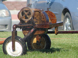
Don spotted this "home made" sprinkler system as we drove in. It seems that the small wheel has water being sprayed up to it; gears inside the small wheel turn the wheel when it is hit by water, which in turn causes the top larger round wheel to rotate around and water comes out of it watering the lawn. A true "Rube Goldberg" was Don's comment, but he loved the system.


Creamer's Field was once the site of Creamer's Dairy Farm, the largest and most successful dairy in interior Alaska. Because migratory birds had been stopping each spring to feast on the fallow fields, when the dairy farm went up for sale the community of Fairbanks raised funds to secure the lands for migratory and local birds The farm today is known as Creamer's Field Migratory Waterfowl Refuge and owned by the State of Alaska--managed for the Department of Fish and Game.


The white building was the original Creamery and now houses exhibits of birds and their amazing migrations, teaching areas, and a nature store.


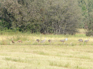
During my couple of visits geese and Sandhill Cranes were the dominate birds. A duck was seen here and there.


Sandhill Cranes cover over 4,000 miles annually in their migratory runs. These Lesser Sandhill Cranes of interior Alaska are about 3 feet tall with a wingspan of 6 feet and weigh 6-8 pounds. The central flyway they use during migration often has an estimated 150,000 to 200,000 birds flying the pathway.

Both sexes are gray however they "paint" their feathers with mud and rotting vegetation creating rusty highlights (above).


The red cap on the head of the crane comes after the first year and can increase or decrease depending on the birds mood.


Watch these cranes for awhile and you have to laugh at their antics. They fluff themselves to appear bigger and extend their wings in preparation to protect or fight, or stand beak to beak posturing. They are comical birds.


The cranes gather (staging) until there are perhaps 50 to several hundred. Taking off the cranes wheel and call while flying high overhead in great circling columns, or "kettles" as they fly over the norther foothills of the Alaska Range heading southward for the winter.


BBFN, Karen and Don